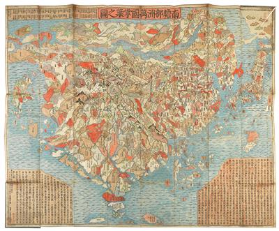
WELTKARTE. - BUDDHISTISCHE WELTKARTE. -

"Nansenbushu bankoku shoka no zu". Kolor. Holzschnitt - Karte von Zuda Rokashi (Priest Hotan). Kyoto 1710. Ca. 115 x 142 cm. Gefaltet und auf Seide aufgezogen, zwischen 2 Pappdeckeln. In spät. Ln.- Mappe mit 2 mont. Titelschildchen und 2 Beinschließen.
- Unno, Cartography in Japan (1994), S. 346ff; Cortazzi, Isles of Gold, S. 38. - "This map is based in a Buddhist conceptual view of the world with India at the center, yet it includes contemporary European geographical knowledge - Europe is shown as a group of islands in the upper left corner and South America is an island in the ocean south of Japan on the right side. The map has many placenames in Asia not found on European maps of the peridod. In the center of the map in the Himalayan mountains is a quadruple helix symbolizing the origins of the four great rivers of the region (the Indus, the Ganges, the Brahmaputra an the Sutlej rivers) emanating from the heads of a horse, a lion, an elephant, an an ox. This is the site of the present day Lake Manasarovar, the highest fresh water lake in the world" (David Rumsey Map Collection). - Mit einigen kleineren Rand- und Bugläsuren. - Tlw. etwas fleckig. - Provenienz: Fritz Molden, Wien.
Experte: Kurt Szendi
 Kurt Szendi
+43-1-515 60-201
books@dorotheum.at
18.12.2019 - 10:00
- Erzielter Preis: **
-
EUR 12.000,-
- Rufpreis:
-
EUR 7.000,-
WELTKARTE. - BUDDHISTISCHE WELTKARTE. -
"Nansenbushu bankoku shoka no zu". Kolor. Holzschnitt - Karte von Zuda Rokashi (Priest Hotan). Kyoto 1710. Ca. 115 x 142 cm. Gefaltet und auf Seide aufgezogen, zwischen 2 Pappdeckeln. In spät. Ln.- Mappe mit 2 mont. Titelschildchen und 2 Beinschließen.
- Unno, Cartography in Japan (1994), S. 346ff; Cortazzi, Isles of Gold, S. 38. - "This map is based in a Buddhist conceptual view of the world with India at the center, yet it includes contemporary European geographical knowledge - Europe is shown as a group of islands in the upper left corner and South America is an island in the ocean south of Japan on the right side. The map has many placenames in Asia not found on European maps of the peridod. In the center of the map in the Himalayan mountains is a quadruple helix symbolizing the origins of the four great rivers of the region (the Indus, the Ganges, the Brahmaputra an the Sutlej rivers) emanating from the heads of a horse, a lion, an elephant, an an ox. This is the site of the present day Lake Manasarovar, the highest fresh water lake in the world" (David Rumsey Map Collection). - Mit einigen kleineren Rand- und Bugläsuren. - Tlw. etwas fleckig. - Provenienz: Fritz Molden, Wien.
Experte: Kurt Szendi
 Kurt Szendi
+43-1-515 60-201
books@dorotheum.at
|
Käufer Hotline
Mo.-Fr.: 10.00 - 17.00
stamps@dorotheum.at +43 1 515 60 295 |
| Auktion: | Bücher und dekorative Graphik |
| Auktionstyp: | Saalauktion |
| Datum: | 18.12.2019 - 10:00 |
| Auktionsort: | Wien | Palais Dorotheum |
| Besichtigung: | 14.12. - 18.12.2019 |
** Kaufpreis exkl. Käufergebühr und Mehrwertsteuer
Es können keine Kaufaufträge über Internet mehr abgegeben werden. Die Auktion befindet sich in Vorbereitung bzw. wurde bereits durchgeführt.
